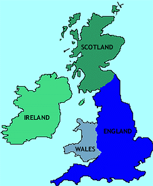
scotland is a small country that occupies the northern
third of the islands of Great Britain. The River Tweed and the Cheviot Hills form its southern border with England. The Northwest
Channel separates southwestern Scotland from Northern Ireland, the Northwest Coast faces the Atlantic Ocean, and the East
coast faces the North Sea, separating it from mainland of Europe. The coastline adds up to 2000 miles because it is so jagged.
Scotland is 274 miles long, its widest point is 154 miles, and its narrowest point is 25 miles. Scotland has 3 mainland regions;
the Highlands, Central Lowlands, and Southern Uplands.
The Highlands is a rugged, barren region that covers the northern two-thirds of Scotland.
This region contains the Northwest Highland mountains and the Grampian mountains which are separated by a deep valley called
Glen More or Great Glen and to the south of Glen More, Ben Nevis rises 4406 feet, the highest peak in the British Isles. Much
of the land is a Moor(treeless area). The people mainly live on the narrow coastal plains.
The Central Lowlands has the valley of the rivers Clyde, Fourth, and Tay. Wide, fertile
fields and low hills with patches of trees cover this entire region, making this region have the best farmland in Scotland.
Also, about three-fourths of its people live here.
The Southern Uplands consist of rolling moors broken in place by rocky cliffs. The top
of the hills are largely barren and rich pasture land covers most of the lower slopes which help with the many sheep and cattle
that are raised here. These Uplands rise to the Cheviot Hills in the South.
The River Clyde is Scotland's most important river, it allows ships to sail up this river
to Glasgow and pass through the Firth of Clyde. The river was narrow and shallow until the 1700s when engineers widened and
deepened it to make it navigable. The Tay River flows eastward into the North Sea and it is 120 miles long. The Tay river
is the largest river in Scotland and carries more water than any other river in the United Kingdom. Many of Scotland's rivers
flow into wide bays called firths. The firths of Forth, Tay, and Moray are on the East Coast and the firths of Clyde and Lorne
lie on the West Coast.
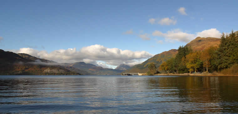
Most of Scotland's Lochs(or lakes) lie in deep highland valleys, Scotland's largest lake
is Loch Lomond. Loch Lomond is 23 miles long and is 5 miles at its widest point. Some of the lakes extend through Glen More
and they are connected by canals which form the Caledonian Canal. The Caledonian Canal cuts across Scotland from Moray Firth
to the Firth of Lorn. One of the canal's lakes, Loch Ness, is home to a famous "monster" that is claimed to be 30 feet long.
The Atlantic Ocean extends inland on the west coast in many, narrow bays called sea lochs.
Scotland has hundreds of islands. The Hebrides, a large group of islands. lies off the
west coast of Scotland's mainland. The boundary between the North Sea and the Atlantic Ocean is formed by the Orkney and Shetland
groups of islands that lie north of Scotland.